Meet the Meteorologist
What's your favorite weather phenomena?
What got you interested in the weather?


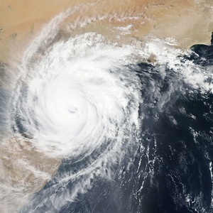
Back before we understood the structure of a hurricane, people that were surprised by these powerful storms would hunker down for the storm as it began. Then, they would notice a sudden break up of the clouds along with a sudden let up in the wind. Thinking this marked the end of the storm, folks would let their guard down and go outdoors. Unfortunately, we didn't have the knowledge to know this was the eye of the hurricane going over them, and that the second half of the hurricane was about to begin. Since we have been in the satellite era of meteorology, hurricanes can now be watched days in advance, and features like the eye of a hurricane can be seen clearly during the hurricane's lifespan. Although the eye of a hurricane is a well known feature in the development cycle of a hurricane, the science behind why it exists is still hotly debated.
The basic physics involved in forming the eye of a hurricane are generally accepted by the scientific community. The first law of physics that is involved is the conservation of angular momentum. This law is what governs the fact that when a figure skater is in a spin and brings their arms inward, they will start spinning faster. Applying this law to a hurricane means that, as you head closer to the center of the hurricane, the speed of the winds around the center increase. This is why hurricane winds are strongest along the edge of the eye, in a region known as the "eyewall."
As the wind speeds increase around the hurricane's center, a force known as the "centrifugal force" comes into play. Anytime you are in a car that is taking a sharp corner, you feel this outward directed force pull you to the edge of your seat. When the centrifugal forces becomes large enough, it basically pulls from the center of the storm outward, leaving a vacuum of air at the center. This creates lower pressure at the center, which draws a portion of the high altitude air leaving the nearby eyewall down into the storm's center. This descending air from aloft scours out the cloud cover at the center of the hurricane, resulting in the cloud-free eye that we are all familiar with.


 Derek Heit
 Jennifer Wojcicki
 Laura Lockwood
 Ray Miller


